Mountain Biking in Wagga, NSW

While it may be surprising to some, Wagga Wagga has a thriving mountain biking community and could teach many of us a lesson or two about creating a sustainable future for our sport. Great mountain bike destinations tend to revolve around the presence of mountains, right? Think of some top places to ride; Mt Majura ACT, Mount Beauty Vic, Mt Cootha Qld, Blue Mountains NSW and so on. Somewhere like Wagga Wagga in the Riverina area of NSW probably wouldn’t strike you as a place to take your mountain bike. Well, in this case looks can be deceiving. Located on the banks of the Murrumbidgee River in southern NSW, Wagga is about 2.5 hours drive west of Canberra and 1 hour north of Albury. Wagga is surprisingly large, with a population of close to 60,000, it lays claim to being the largest inland town in NSW. It is the home of the Charles Sturt University, TAFE NSW Riverina Institute, as well as large Army and Air Force bases. When you add the local rural community to the mix, you get a population that tends to be a little more ‘cosmopolitan’ than most country towns. Wandering down the main strip you will encounter uni students, academic types and leather-skinned sun bleached farmers. On the streets the ‘lappers’ in their lowered cars compete for space with the B & S ball utes—it is a real mix. There is also a burgeoning café community with coffee shops and restaurants popping up all around the place. Safe to say that Wagga is not the dead back water that so many country towns are at risk of turning into with the drought and the influx of people to the cities. There are no real mountains in the region and the nearby hills are lucky to offer more than 150 metres of variation in elevation. What Wagga lacks in topography it makes up for in its strong mountain bike community. MTB Wagga is the local mountain bike club. While the club was only established in 2005, they have close to 100 members and are still experiencing consistent growth. The monthly club XC races average 50 or 60 riders which is good going for any MTB club. A strong mountain bike community needs a good network of trails and this is one of Wagga’s strong points.
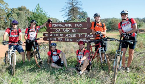
While MTB Wagga is relatively young, other clubs could learn a lot from them and the way they have handled trail access issues in their region (see ‘Fighting for Livingstone’). Through hard work, persistence and prudent planning they have earned a number of formally recognised riding areas. With consent of their local council they have developed and maintain a network of trails around the Pomingalarna Reserve—the Mayor actually started the recent 3 hour enduro that was held there. Mountain bikers are able to ride the multi-use trails at Willans Hill as well as the Wiradjuri walking track. They have also earned legitimate access to Rural Lands Protection Board sites including Plum Pudding and Brick Kiln Reserves.
Probably their biggest win has come at Livingstone National Park. The recently released Draft Plan of Management recognises mountain biking as a ‘legitimate recreational pursuit’ and it appears as though access to the network of singletrack will be retained. This recognition of mountain bike use on ‘single lane trails’ as they call them, bucks the trend of National Parks and Wildlife in NSW where singletrack is normally off-limits. I thoroughly enjoyed my two days of riding in Wagga. This was only enough to get a taste of the riding on offer and it looks well worth a trip to explore it a little further. I met up with the guys from MTB Wagga one weekend and rode at Willans Hill, Pomingalarna, part of the Wiradjuri walking track and a portion of Livingstone National Park. This was a solid two days of riding and there is plenty more on offer. The trails in most areas are unmarked, so the best way to get the most out of the area is to hook up with the locals.
On any given weekend, it shouldn’t be too hard to tee up a ride with some MTB Wagga club members via their website, www.mtbwagga.asn.au they are a super keen group of riders. If you want to go it alone and find some trails, your best bets are Pomingalarna, Willans Hill or Wiradjuri. Here’s a summary of what to expect:
 Willans Hill
This is the area where the locals go for a quick afternoon blast. Willans Hill is a reserve or green belt that runs right through the middle of residential Wagga. It may only be a kilometre wide and a few kilometres long but it has a network of multi-use trails for hikers, bikers and dog walkers. Some of the trails are quite fun with nothing too challenging so it is a good place for beginners. The best part for an ‘out of towner’ is that you won’t get lost, well not drastically lost as the hill offers good views over Wagga so you will always find your way out. You can download a trail map of Willans Hill from www.mtbwagga.asn.au/maps.php.
Wiradjuri

The Wiradjuri Walking Track is a 30km long multi-use track that caters for walkers and bikes. For the most part it is a nontechnical but enjoyable ride, although you will encounter the occasional step or rock drop here and there. The walk is easily found near the centre of Wagga as it skirts the banks of the Murrumbidgee River and goes right past ‘Wagga Beach’—that’s where everyone goes for a dip on a hot day! Maps and details can be obtained from Wagga’s Visitor Information Centre on Tarcutta Street. The trail has a number of access points and you can use it as a pleasant way to get to other riding areas such as Willans Hill, Pomingalarna or Brick Kiln Reserve.
Pomingalarna
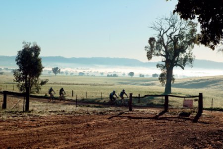
Pomingalarna Reserve is on the western outskirts of Wagga, just off the Stuart Highway. The best access point is just past the Golf Club on the right hand side as you head out of town. Follow the management track in and the main singletrack veers off to the left hand side and switchbacks up the communications tower hill. While the track is not officially marked, you will find arrows at reasonable intervals as it is ridden frequently by club members and the main 10.5km loop was the venue for the recent 3 hour event. A map of the 3 hour track is currently on the MTB Wagga website: www.mtbwagga.asn.au/3hour/course.php there is still a fair chance of getting lost if you aren’t familiar with this area—the map is not the best and there are lots of other tracks in the area to confuse you.
If you can’t tee-up a ride with a local, do your best to follow the course markings, but leave plenty of time for any ‘navigational errors’. Use the communications tower as a reference point as it is right above the golf course. The trail loop around Pomingalarna provides good value entertainment. It is predominantly singletrack and flows nicely with some cool gullies that can be great fun when tackled at speed. The final descent back to the golf course is by far the best part. It is an amazing roller coaster ride that spits you out at the bottom begging for another go—top fun for sure!
Plum Pudding
Plum Puddins is on the right hand side of the Wagga-Mangoplah Road 13km south of the Red Hill Rd roundabout in Wagga. This area of native bushland contains around 10km of singletrack and is a regular venue for MTB Wagga club events. The trails are not overly technical and it is a good area to explore.
Brick Kiln
This is a relatively small riding area in a reserve to the east of Wagga. Head east out of Wagga on the Sturt Highway for a couple of kilometres, then turn left into Eunony Bridge Road at Gumly Gumly. The reserve is off Eunony Bridge Road just behind the Carriage House Motor Inn. The trails weave through the bushland on the banks of the Murrumbidgee River.
.jpg)
Livingston National Park
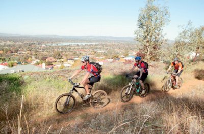
The jewel in Wagga’s crown, Livingston National Park is an area of native bush approximately 30km south of the city. While it is only 6km long and 3km wide, it contains enough riding to keep you going all day and then some. The park is crisscrossed with fire trails but the main attraction for mountain bikers is the singletrack. Over the years local dirtbikers have made a number of singletracks that link one fire road with the next. Livingstone was only declared as a National Park in 2005 and Parks and Wildlife are keen to get the dirtbikes off the singletracks and restrict them to the management trails. It appears as though the network of motorbike made trails will be slated as multi-use trails for walkers, horses and mountain bikes. MTB Wagga has spent a lot of time researching the trail network to determine which trails are sustainable, which need rerouting and which need to be shut to limit erosion. This has been presented to the park management and the MTB club is offering their volunteer labour to make it happen.
 This is obviously work in progress and National Parks may still change their minds, but it appears as though the cooperation and open communication will result in legitimate MTB access to singletrack in this area. The trails have all been surveyed, mapped and named by MTB Wagga— names like Cindy’s, Pod Racer, Rock Garden and RSFG (Rocky, Sh!ty, F@#king Gully). The trails are not currently marked and at this stage MTB Wagga wouldn’t appreciate hordes of riders flocking to Livingstone. It is also very easy to get lost in the area as the low ridges don’t offer many vantage points where you can get your bearings. At this point, the last thing anybody needs is a search and rescue for a lost mountain biker in Livingston. Once the Plan of Management has been formalised, trail maps should become readily available.
In the meantime, hook up with the locals to ride in Livingstone as they will show you the best trails on offer. Livingstone is rocky in places and the trails are more technically demanding than Wagga’s other riding areas. While the maximum altitude variation is no more than 150m, there are plenty of testing hill climbs and some wonderfully flowing singletrack descents. Cindy’s is a local favourite as is Pod Racer.
The main access point for the Livingstone trails is behind the gun club on Wrigley’s Road. Drive approximately 30km south of Wagga on the Wagga-Mangoplah Road, turn left onto O’Brien’s Creek Road then right onto Wrigley’s Road. As mentioned previously, it is best to tee up a ride with the locals. That way you won’t miss any of the good trails! If you want to ride the area without the benefit of local knowledge, be very wary. Tales abound of riders getting lost and emerging from the bush at 10pm. Make sure that you start early, take a compass and allow plenty of time to get out as you will wind up directionally challenged.


 Willans Hill
 The Wiradjuri Walking Track is a 30km long multi-use track that caters for walkers and bikes. For the most part it is a nontechnical but enjoyable ride, although you will encounter the occasional step or rock drop here and there. The walk is easily found near the centre of Wagga as it skirts the banks of the Murrumbidgee River and goes right past ‘Wagga Beach’—that’s where everyone goes for a dip on a hot day! Maps and details can be obtained from Wagga’s Visitor Information Centre on Tarcutta Street. The trail has a number of access points and you can use it as a pleasant way to get to other riding areas such as Willans Hill, Pomingalarna or Brick Kiln Reserve.
.jpg)
 This is obviously work in progress and National Parks may still change their minds, but it appears as though the cooperation and open communication will result in legitimate MTB access to singletrack in this area. The trails have all been surveyed, mapped and named by MTB Wagga— names like Cindy’s, Pod Racer, Rock Garden and RSFG (Rocky, Sh!ty, F@#king Gully). The trails are not currently marked and at this stage MTB Wagga wouldn’t appreciate hordes of riders flocking to Livingstone. It is also very easy to get lost in the area as the low ridges don’t offer many vantage points where you can get your bearings. At this point, the last thing anybody needs is a search and rescue for a lost mountain biker in Livingston. Once the Plan of Management has been formalised, trail maps should become readily available.

