
Mountain Biking near Jenolan Caves, NSW
In the absence of the Polaris Challenge, Martin Geliot and his cohorts set off on their own adventure, finding some great riding in the Jenolan area.
Knowing there is a lot of really good riding at the top of the Six Foot Track, our regular riding crew took a close look at the Jenolan and Hampton topographic maps to scope out the options. There’s a huge network of forestry tracks, fire trails and lightly trafficked minor roads to choose from. Settings range from snow gum forests to dry sclerophyll forest and open farmland. The difficulty level can vary substantially—from easy beginners’ rides to full on epics with a splash of adrenaline thrown in. The section of the Six Foot Track (SFT) between the Cox’s river and Megalong Valley is particularly sensitive and MTB access to that section is under close scrutiny at the moment, so we decided to map out a loop that avoids traversing that section. As a bonus, it avoids the nuisance of a car shuttle by starting and ending at the Black Range campground, which is a popular starting point for doing the SFT. We decided to use the not-so-vulnerable fire trail portion of the SFT almost down to Cox’s River. From there we aimed to work our way north, paralleling the river to link up with a selection of tracks and road options that climb back up towards the Black Range. There’s great informational signing at Black Range, and the SFT is discreetly marked along the way. So anyone can find their way along the heritage track, especially with the aid of the very informational map sold especially for the SFT. You can purchase this map at the information centres at Glenbrook and Blackheath.

Ride Options
If you like, simply ride down the SFT as far as you wish and then ride back up. While this sounds easy enough, it is a seriously big descent that transforms into a killer climb on the return journey. Otherwise, if you don’t fancy the huge up then you can enjoy the network of forest trails up top. For example a 6km loop is possible by riding only 3km down the SFT then turning right and navigating to return to the top. For just a few dollars Robert Sloss’ booklet ‘Jenolan Caves and the Six Foot Track’ describes numerous ride and walk opportunities, including easy ones which would be suitable for families with children.
The trickiest navigation part could be in the car as the Black Range campground is not signposted from Jenolan Caves Road. So for that reason alone, buying a proper map is a good move. There are some signs visible from the road though—advising of shooting in the forest. We wondered how many ute-loads of piglets had been released so there would be something to shoot, and this must have been going on for a while as an old alternative way in is called the ‘Pig Cage Track’. There are also signs after the campground on the Jenolan Caves Road showing where the SFT crosses. If you see those then you can either ride in from there, or turn your car around because the Black Range campground is just a little way back up the road towards Sydney. We got going about 9:00 in the morning and it was only 12 degrees despite being the middle of summer. So carry plenty of clothing and some sustaining food and drink of course. Even in the cold, you will need plenty of water for the climb out.
Upper Six Foot Track
The ride commences on pine forestry tracks and quickly changes to natural sclerophyll skirting the edge of the Kanangra Boyd National Park. It is possible to pick up a lot of speed but take care as the track is popular with other users—you will find marathon runners, parties of hikers and motorcyclists using the route as well. It is very much a shared space and we found everyone got along really well.
Little River & Alum Creek
After chatting with a party of bushwalkers at the pluviometer (rain gauge), the SFT continues downhill to Little River, which it crosses multiple times before crossing Alum Creek and starting the climb of Mini-Mini Saddle. We don’t understand why the SFT is so popular with walkers—there are far better walks, and cycling it is easier and more fun. Perhaps they’ll figure it out one day? About a kilometre after the pluviometer (marked on the Jenolan topo map) a left turn off the SFT would provide another loop ride back to Black Range; either via Beefsteak Creek or along alternative tracks that take you back into the pine forest. This looks like a great one for the crew to try another day—especially if we do it right and take a stove with some good scotch fillets. Mmmm! Oh and not to forget the easy-to-carry port. The contours are already challenging, having descended from around 1,200m to 700m at Little River. The return journey would involve a lot of climbing—it is well worth adding the up contour lines on the topo map before committing to the out and back route! Back to our SFT ride… The first couple of Little River crossings were an easy ride, despite a pretty good flow in the river. The next was not going to be so easy as it had rained recently. It looked likely to get my precious bearings wet and there were some big slippery rocks that threatened to tip me off. I hopped my bike and walked through whilst some of our party attempted a dry feet rock step tap-dance. It’s curious that this river is Sydney’s drinking water, and walking in it is perfectly OK, yet cycling on a 4WD fire trail in another location up the mountains which is kilometres from watercourses is deemed illegal by the Sydney Catchment Authority. Bizarre!
 Mini-Mini Saddle
We have no idea why it’s called Mini-Mini—it’s actually steep and far from ‘mini’. Mini-Mini Saddle is the first bit of hard work on the SFT route down from Black Range. Once this climb has been crested there’s more descending and whoa… good brakes important! I did this once in heavy rain a few years back and by this stage my brake pads were gone—lots of no-brakes footwork was required to control the speed! The track also becomes quite rutted due to water runoff on steep sections with little done to control it. You either have to travel quite slowly and pick an easy line or hop over the ruts at speed. One of these ruts, near the Alum Creek, was a metre deep and 300mm wide—we could see why motorcyclists had developed a diversion. Rutted track conditions exist for much of this steep section, on account of a lack of measures to mitigate water runoff. Yet later in our ride, steeper tracks with excellent drainage measures weren’t rutted at all. It’s worth remembering that much of the heritage SFT involves using land that has been negotiated for access with private landholders by the Orange Lands Department—it used to be fenced off. So the lowest possible impact riding techniques are very much in order, as well as being respectful of other users in the area, livestock and of course closing gates. Although suffering terribly from weeds in many places it is still worth being careful to avoid distributing weed seeds on your clothing. So remove any seeds you pick up and stow them if possible—zip-lock bags work well for this. Finally the forest changes to farmland and the views open up. We took a good look at our maps, as before long our turn off to leave the SFT and head up to Kiangatha homestead would be upon us—we didn’t want to miss it.
Kiangatha Homestead to Sandy Hook
At the yards for the Kiangatha (also spelt Kyangatha) property the SFT bears right. We went left to start our undulating loop route to the north. The track is very well signed as the ‘wrong way’, even though it was the ‘right way’ for us. Even more confusingly, at least one of the farm gates is marked ‘6ft’ even though it isn’t part of the SFT. Maybe the original SFT went that way but who knows? This section takes you through numerous farm gates but it is a legitimate right of way so you are allowed to ride there. There are a fair few side tracks, especially ones in place to service powerlines. We found our way easily enough with the topographic maps and backed up any uncertainty at intersections by referencing our position from a GPS. The views across the Kanimbla Valley are tremendous and it is really nice not to hurry!
Once you leave Kiangatha the road really does become a ‘road’, complete with school bus signs. There’s a choice of routes; a hilly one to the western side and the easier eastern route that we took. It provides quick riding that takes you down to the quaint locality of Sandy Hook; complete with tennis courts and an old church. This is where our route turned onto Table Rock Road. Some locals we met along the roadside were very helpful—they confirmed our chosen route up Table Rock Road was viable although steep. We were also told about the remains of Peter O’Reilly’s place, abandoned since he and his family moved to Queensland to open the now famous ‘O’Reilly’s’ resort in the Lamington National Park. Apparently his kitchen is still standing but that’s about all.
From Sandy Hook point there are a few options. Arranging for a car pickup at the church would be a great idea for those who are not keen on the 800 metres of height gain required on the return to the Black Range campground. With two cars you could do a relatively short and simple ‘car shuffle’ by leaving a vehicle at Sandy Hook on the way out. Although finishing at Sandy Hook would cut the ride to about 25km in total length and eliminate 85% of the climbing, you still shouldn’t underestimate the terrain—your legs will probably be feeling as the climb of Mini-Mini Saddle and the ‘undulations’ near Kiangatha are enough to make this a solid ride. There are plenty of nice spots for a car based picnic, so a car loaded with fresh bread and brie would be just the business! You can also make your way back to Jenolan Caves Road via Cullenbenbong Road and Marsden Swamp Road. This provides a reasonably long and simple to navigate route back to the top of the range—it carries little traffic and would be quite a nice ride for another day. This route completes the western Six Foot Track Loop while avoiding any areas that are questionable in regards to private property.
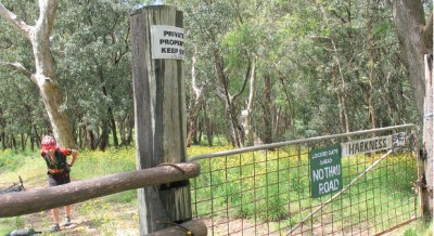
Table Rock Road
We can’t endorse the adventure that followed for our ride party but will tell the tale all the same—it serves as a good illustration of the difficulties that you can encounter when navigating your way through an area such as this. Although the climb up Table Rock Road begins easily enough, the road soon changes to a track and we needed to locate a left turn just after homemade signage not-tooptimistically indicating ‘No Thru Road’. Confirming our position with GPS was helpful once again. We took the sign to mean that the route was closed to cars, and sure enough some of the gates had government utility locks on them. Unfortunately you can’t tell from topographic maps if a track is a right of way or not. As there was no ‘private property keep out’ sign and the locals at Sandy Hook didn’t hint at any complications, we felt good to go. We passed our bikes over the locked gate and pressed on, enjoying a monster height gain of around 700 metres in just a few kilometres! Some in our party rode the lot, some walked a bit. Next to the locked gates fencing had been flattened, presumably by walkers expecting the route to be open. Although tough work, the height is not lost and then regained as the track just goes up. The views over the tracks we had ridden and off towards the Blue Mountains were huge—well worth the effort. There was a house towards the top which appeared to be deserted. Despite being a cool day, we had used most of our water, so it was time to fill up. The trusty water filter meant we could overlook a little scum and replenish supplies from an old concrete cattle feeder—the drinking was good too; much nicer than treated tap water. After leaving the property we discovered a sign saying ‘private please keep out’. By this time it was too late, as we had traversed the property and were leaving it rather than going in! Upon returning home, further reserch and multipule phone calls revealed that this trail was infact through private land and not a public access route.
Bush rider’s Finish
From there we continued along the Table Rock fire trail, and then used the fast riding along Mini Mini Forest Road to get back to the Jenolan Caves Road. Mini Mini Forest Road turfed us out a few kilometres north from the Black Range and a rapid road ride got us back to our cars. A more agreeable route through the forest could be worked out but we weren’t too sure if the pig hunters would be taking pot-shots at anything that moved! Our ‘illegal loop’ took us just over six hours to complete, covering a distance of around 45km. The suggested loop via Cullenbenbong Road, Marsden Swamp Road and Lowther would take the ride distance up to 75km, but the faster road sections and easier navigation would lift the average speed. Be prepared for this ride to take longer in hot conditions as the open farmland areas get rather oppressive once the mercury climbs. Sustenance was very high on the priority list after this big energy burn and we enjoyed a brief stop at the Austrian run café in Hampton a little way up the road. Their egg-and-bacon roll was first class, washed down under the gaze of many pictures of Her Majesty. The owner immediately cottoned on that we were really bushwalkers with bicycles, so he coined the term ‘Bushriders’ for us -so true. We had such a great day that we decided to make a routine of doing discovery epics like this one and would be back in the area soon for more.


